Genesis and Maintenance Processes of a Quasi-Stationary Convective
Band that Produced Record-Breaking Precipitation in Northern Kyushu, Japan on 5 July 2017
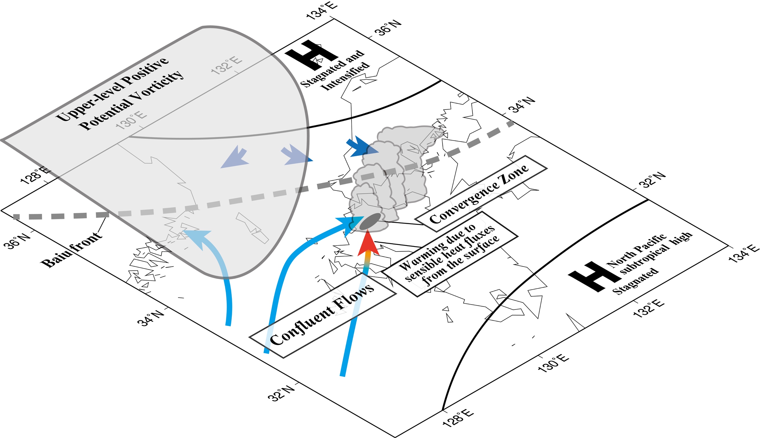
A quasi-stationary convective band that was sustained for approximately ten hours caused precipitation in the northern part of Kyushu Island,
Japan on 5 July 2017. This extreme amount of
rainfall produced by the convective band caused a number of landslides and flash floods,
resulting in a severe disaster. The Weather and Research and Forecasting (WRF) model was used to
perform numerical simulations and clarify the genesis and maintenance processes of the convective band.
A full-physics WRF simulation successfully reproduced the observed features of the convective band and
extreme precipitation. It is shown that a quasi-stationary convergence zone in the low level played
a crucial role in generating and maintaining the convective band. Trajectory and frontogenesis analyses
showed that low-level confluent flows due to the blocking effects of a high pressure located in
the Sea of Japan were responsible for the formation, intensification, and sustenance of the convergence zone.
Furthermore, a frontal structure of the convergence zone was intensified due to the land-sea thermal contrast
between Kyushu Island and the Tsushima Strait.
Two additional experiments, a simulation with flattened
topography of the Kyushu Island, and a simulation without considering the evaporation of raindrops,
also reproduced the observed band well. These results indicate that topography and a cold pool due to
raindrop evaporation played only minor roles in the genesis and maintenance of the convective band.
2017 年7 ⽉5 ⽇に九州北部地⽅で準停滞性対流バンド(線状降⽔帯)が発⽣し,
約10時間も持続した。
この線状降⽔帯による記録的な豪⾬によって多数の地滑り・洪⽔が引き起こされ,甚⼤な被害が発⽣した。
本研究では,この線状降⽔帯の発⽣・維持過程を明らかにするために,
Weather and Research and Forecasting (WRF)モデルを⽤いた数値シミュレーションを⾏った。
コントロール実験は観測された線状降⽔帯と極端降⽔の特徴をよく再現した。
停滞性下層収束帯が線状降⽔帯の発⽣・維持に決定的な役割を果たしていた。
流跡線解析と前線形成関数解析は,⽇本海上の⾼気圧のブロッキング効果によって⽣じた下層合流場によって,
この収束帯が発⽣・強化・維持されていたことを⽰した。
また,この収束帯の前線構造は九州と対⾺海峡の海陸間熱的コントラストによっても強化されていた。
九州全域の地形を平坦化した実験と⾬滴蒸発過程を除去した実験も観測された線状降⽔帯を再現した。
このことは,九州地⽅の地形および⾬滴蒸発による冷気プールは本豪⾬事例の線状降⽔帯の発⽣・維持に果たす役割は副次的にすぎないことを⽰唆している。
*Please refer to the following manuscript.
*詳細は下記論文を参照してください。
Kawano, T., and R. Kawamura (2020):
Genesis and maintenance processes of a quasi-stationary convective band that produced record-breaking precipitation in northern Kyushu, Japan on 5 July 2017.
Journal of the Meteorological Society of Japan, 98, https://doi.org/10.2151/jmsj.2020-033